I-10 Accidents Today — Live Corridor Watch
Quick answer: 0 news reports naming the I-10 in the last 24 hours, 4 in the last 7 days; 30 official live incidents on or near the road right now; 1 geocoded report within 20 km. The I-10 is the southern transcontinental interstate through Los Angeles, Phoenix, Tucson, El Paso, San Antonio, Houston, New Orleans and Jacksonville.
Latest reports naming the I-10
News items from the last 7 days whose headline names the road, country-matched. Every item links to the publisher.
Live incidents on or near the I-10 right now
Transport-authority and traffic-data incidents within 20 km of the centreline, nearest first.
| Source | Area | Details | km from road | |
|---|---|---|---|---|
| CHP / Caltrans QuickMap | California | Trfc Collision-1141 Enrt — SR60 E / FAIRWAY DR | 0.6 | |
| ADOT | Arizona | Debris on I-10 Westbound Near N 43rd Ave (MP 141). | 0.6 | |
| MapQuest | Los Angeles | — | 1.4 | |
| ADOT | Arizona | Crash blocking the intersection on I-10 Westbound Near E University Dr (MP 151). | 1.8 | |
| ADOT | Arizona | Guardrail damage on I-17 Southbound Near Durango St (MP 198). | 2.5 | |
| ADOT | Arizona | Guardrail damage on I-10 Westbound Near 202-LOOP Westbound (MP 147). | 3.1 | |
| CHP / Caltrans QuickMap | California | Trfc Collision-No Inj — Sr60 W / S Diamond Bar Blvd Onr | 3.2 | |
| CHP / Caltrans QuickMap | California | Trfc Collision-No Inj — 28896-29033 Thousand Palms Canyon Rd | 3.2 | |
| ADOT | Arizona | Debris on the left shoulder on 202-LOOP Westbound Near 24th St (MP 1). | 4.3 | |
| ADOT | Arizona | Crash on the right shoulder on I-10 Westbound Near SR-143 (MP 154). | 4.6 | |
| DriveTexas | Texas | Closure: RM0335, 5.418 Miles North of RM2631 on RM0335 | 4.7 | |
| DriveTexas | Texas | Flooding: RM0189, 14.369 Miles East of SH0163 on RM0189 | 4.7 | |
| ADOT | Arizona | I10 @ S WATSON RD EB ON ,BUC - AccidentIncident - medical emergency | 5.1 | |
| DriveTexas | Texas | Flooding: US0090, 1.338 Miles East of SL0013 on US0090 | 5.4 | |
| CHP / Caltrans QuickMap | California | Trfc Collision-1141 Enrt — I405 S / N Church Ln Ofr | 5.8 | |
| ADOT | Arizona | S CENTRAL AV/W EUCLID AV ,PHX - AccidentIncident - injury accident | 5.8 | |
| ADOT | Arizona | Incident on I-10 Westbound Near Ehrenberg (MP 1). | 6 | |
| DriveTexas | Texas | Closure: FM0806, 2164.8 Feet South of IH0010 on FM0806 | 6.3 | |
| CHP / Caltrans QuickMap | California | Trfc Collision-Unkn Inj — SR111 / Tipton Rd | 6.6 | |
| MapQuest | Los Angeles | — | 6.8 | |
| MapQuest | Los Angeles | — | 8.2 | |
| DriveTexas | Texas | Closure: FM1458, 2212.32 Feet South of IH0010 on FM1458 | 10 | |
| ADOT | Arizona | Debris on the left shoulder on 202-LOOP Westbound Near Desert Foothills Pkwy (MP 60). | 10.1 | |
| ADOT | Arizona | N 98TH LN/W OLIVE AV ,PEO - AccidentIncident - injury accident | 10.9 | |
| ADOT | Arizona | Agency: Tucson Airport Authority Police DepartmentLocation: 7250 S TUCSON BL; C24; B10Beat: S1 APStatus: deputy en-route - Public Assist | 11 | |
| ADOT | Arizona | Crash blocking the HOV lane on I-17 Southbound Near Northern Ave (MP 207). | 11.1 | |
| CHP / Caltrans QuickMap | California | Trfc Collision-Unkn Inj — Sr91 W Wo / Coal Canyon Rd | 11.4 | |
| DriveTexas | Texas | Closure: RM0189, 158.4 Feet East of SH0163 on RM0189 | 11.9 | |
| ADOT | Arizona | Debris on the left shoulder on I-17 Southbound Near N Black Canyon Hwy (MP 208). | 12.1 | |
| DriveTexas | Texas | Flooding: IH0035, 1.626 Miles East of SL0353 on IH0035 | 12.2 |
Accident reports placed within 20 km of the I-10 (24 h)
City-level placements from the live feed — the dot marks the city named in the headline, not the exact carriageway.
Live traffic cameras along the I-10
Public traffic-camera snapshots nearest to the latest geocoded reports on this page, straight from the transport authority. Images refresh on their own schedule (seconds to minutes); a camera is picked by distance and is not necessarily pointed at the incident.
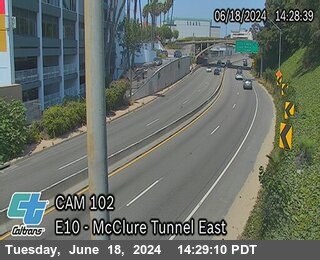


Camera data: Caltrans (California Department of Transportation) (all 2,836 cameras) · AZ511 / Arizona Department of Transportation (all 644 cameras) · 511LA / Louisiana DOTD (all 336 cameras). Snapshots are served by the authority and are not stored by this site. Cameras marked Live video play inline; the rest are still images refreshed by the authority.
I-10 accident history
Recorded fatal crashes (NHTSA FARS 2020–2024) on this road by year, severity, road user, place and time of day.
I-10 — FAQ
Is there an accident on the I-10 today?
Where does this I-10 page get its data?
How is 'near the I-10' defined?
What should I do if I am in a crash on the I-10?
Corridor pages are computed from feeds already on this site (official incidents, news, cameras) — nothing here is estimated. Country context: United States accidents today.